It’s not often that Atlantic Canadians should be happy about a cold front moving into the region in early July, but they definitely should this week.
Were it not for a front making its way down from the northwest over the next three days adding a degree of predictability to the various forecast models, the effects of tropical storm Chris might be much more severe throughout Nova Scotia, Cape Breton and Newfoundland.
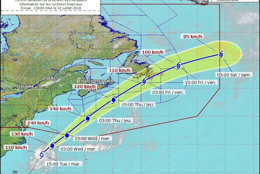
“Sometimes there are no systems steering other systems around an advancing tropical storm or hurricane and that allows it to wobble a little bit and that can change the expected track,” explains SaltWire Network meteorologist Cindy Day.
“But with this one, there's a cold front that's coming down from the northwest pushing towards the southeast. There really is no big option for the track of this storm, it's going to continue to take on that northeasterly direction, picking up speed and weakening.”
If the current track holds true — placing it south of Sable Island, 300 kilometres southeast of Halifax — Day says mainland Nova Scotia and Cape Breton will only be brushed by the approaching storm that will have gained and lost Category 1 hurricane status by the time it reaches the colder Maritime waters.
It will likely weaken to a post-tropical storm as it approaches the Avalon Peninsula overnight Wednesday and into Thursday.
Between Wednesday night and early Thursday, Day is forecasting five to 10 millimetres of rain for Nova Scotia, with the potential for up to 20 millimetres in Cape Breton. The strongest winds will be in eastern Cape Breton, gusting from the north at 50 to 60 km/h.
Prince Edward Island, Day says, shouldn’t experience more than heavy cloud and some breezy conditions.
While the Maritimes are mostly unaffected, the same can’t be said for Newfoundland, particularly the Avalon Peninsula, which will feel the full effect of what’s left of Chris by the time the storm makes it to the even colder waters off the province’s southeast coast.
“Once it hits the colder water and starts to unravel, its forward motion increases as the winds decrease. It should bring some rain to the Avalon by the middle part of the day on Thursday and then we'll be back to sunshine shortly after sunrise on Friday.”
Communities on the Avalon can expect to receive 20 to 30 millimetres of rain, possibly a little more if the system slows down.
Southeastern winds will increase and gust to roughly 80 km/h overnight Thursday before switching over to northwesterly gusts of 70 km/h by Friday morning. That will result in some cooler temperatures throughout the weekend, but Day says it’ll be mostly dry.
The rest of the island can expect isolated showers, breezy conditions and relatively warm temperatures.
The Department of Municipal Affairs and Environment is monitoring the storm ahead of its arrival and is encouraging residents to prepare and maintain an emergency kit that can service their needs for at least 72 hours.
The government is also reminding residents to follow the latest weather forecast for alerts and warnings.
Twitter: kennoliver79