BRIDGETOWN, N.S. — The Department of Transportation and Infrastructure Renewal (TIR) has a number of roads that are almost never used anymore for the purpose of transportation – nor will they be seeing any kind of significant renewal.
Those roads, classified as K-class roads by the province, range from rarely used public roads that are no longer maintained, to ancient abandoned passages partly retaken by the forest. There are about 2,500 km of these in Nova Scotia.
Many of these old roads are artifacts of a bygone era, and Steve Skafte of Bridgetown is something of a curator and chronicler of their history.
Skafte oversees several groups on Facebook that explore some of the quieter, abandoned spaces in the Valley, such as Abandoned Nova Scotia and Abandoned Roads of Nova Scotia.
“I grew up down the road from Phinney Mountain Road, which runs over North Mountain from Beaconsfield to Phinney’s Cove,” said Skafte. “We used to hike it on and off as kids and that’s one of the roads in the new book.”
It was an awareness that “everyone knew about one or two abandoned roads near them, but nobody really seemed to be hiking them” that compelled Skafte to begin exploring those roads on foot.
“I started looking at property records and realized there are a lot of them. Not provincial park trails or logging roads or snowmobile systems, but roads you can walk where you can find old foundations or places people used to live – remnants of what’s left behind with real history.”
Along with old roads, Skafte is fond of exploring little-known spaces that have the same quiet history embedded in them – like old draft dodger hideouts on the slope of North Mountain.
LOSING HISTORY
Being aware of some of the old roads and places in the Valley that have long been forgotten and left to the whims of time and nature has given Skafte a sense of urgency in his work. This urgency is driven by the fact that many of the places he discovers are often overlooked.
“People can go to Fort Anne at Annapolis Royal and all that is preserved, but there was this abandonment at the end of the 20th century, and people have only saved some of these places through photographs,” Skafte said.
One example of this that stands out for Skafte is the long-abandoned Britex factory near Bridgetown.
Finding an abandoned box of photographs, he shared them on the internet, and they achieved almost-viral status with thousands of people with connections to the old factory sharing them.
“It’s history that would be just sitting there, being forgotten about, because historians look at things like train history, or colonial or war history,” Skafte said. “I feel like we’ve been ignoring everyday history.”
His new book, This Creek Was Once a Street, is his remedy to the historical voids that he sees in the Valley.
Specifically, This Creek Was once a Street focuses on the old roads that never had power lines on them and may have only been wide enough for horse-drawn carts – streets that started getting abandoned in the '60s and '70s.
EXPLORATION
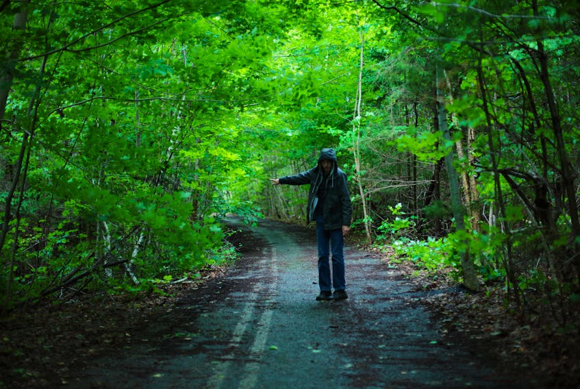
“I wanted to explore every inch of the area, and drove every road I could in Annapolis County, Kings County and Digby County,” said Skafte. “Once that was done, the only thing left was to hike the roads that I couldn’t drive.”
Although TIR keeps the roads for various reasons, such as property access, Skafte has made an art of exploring and documenting what he has found when walking along these rarely-used routes. His book contains specific directions, names and GPS coordinates for anyone who wishes to stroll down the lanes of history.
When asked about the name of his book, Skafte said the idea came to him after watching what resulted when many old roads eventually flooded, ditches filled in and what was once a street slowly became part of a waterway.
“It’s common for new bodies of water to reclaim them, with some of the water drainage down the mountainsides,” he said. “They get washed out and merge with other streams.”
He hopes his newest book helps people explore and find some of these old roadways, no matter what shape they’re in, and he emphasizes that they are public property.
“I don’t offer GPS coordinates when I post or write about old houses,” he said, alluding to a strict policy on Abandoned Nova Scotia, whereby members are advised not to disclose the location of abandoned spaces they find.
“If I don’t tell people where these roads are, and if they’re not hiked, they won’t stay open,” Skafte contended. “I hiked one near Wolfville and had to break a bunch of alder branches and things. If they aren’t hiked, they won’t be visible.
“That would be a shame, if they disappeared, because they tell a certain kind of history, along with the rocks piled by the shoulder or 100-year old trees covering a former field.”
To purchase a copy of This Creek Was Once a Street, visit Skafte’s Etsy shop page