A Saint Mary's University archeologist says advances in computer modelling are proving to be powerful research tools as well as an exciting way to engage the public about Nova Scotia's past.
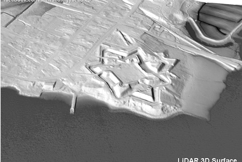
Jonathan Fowler, an associate professor at Saint Mary's, recently released details of how LIDAR imaging can be combined with digital mapping to reveal new details of historic places like Fort Anne, a national historic site in Annapolis Royal.
LIDAR, or Light Detection and Ranging, uses a pulsed laser to measure precise ranges for Earth surface 3D imaging, often from an airplane or helicopter, according to the National Ocean and Atmospheric Administration (https://oceanservice.noaa.gov/facts/lidar.html).
Fowler said Saint Mary's has been working to integrate new technologies like remote sensing into their research program for a while.
“This is the sort of thing that we're always trying to do, is integrate the newer technologies, more powerful newer technologies, new ways of seeing the past,” Fowler said in a telephone interview on Tuesday. “And last year, especially – 2020 – the Nova Scotia government released great volumes of free, open data, LIDAR data, which, well, it just felt like Christmas to me."
The LIDAR came through data freely available from the government website's Data Locator - Elevation Explorer (https://nsgi.novascotia.ca/datalocator/elevation/). There are multiple squares on a map of the province and clicking on a given square will allow raw data to be downloaded.
“It was just a remarkably rich body of data that covers most of the province at this point.”
It allows researchers to re-examine well-known archaeological sites and features as well as sites that have not had a lot of terrestrial work done.
“Earthwork sites like Fort Anne are terrific sites to explore with this method because they appear so vividly in the data and you can process the data in such a way to remove obstacles, like modern buildings and vegetation, and you can focus on details of micro-topography that often will give evidence of features under the surface that you wouldn't even notice if you were on the surface – things like very slight undulations in the surface – that will appear in the data if you can tease it out.”
He's been doing that for the past several months, working with Golden Software, a firm based in Colorado, that has a software package that allows them to do that kind of work and create “Quite beautiful maps,” he said.
One of the features of the software is texturing mapping, which allows historic maps to be draped over top of the LIDAR image or even historical aerial photography.

“If you've got old photos from the 1940s or something like that, you can drape those over the landscape as well and basically create a much more immersive and vivid 3D environment that is historical.”
The software is such a powerful research tool because it allows archeologists to collate different sources of information in a seamless way, such as the LIDAR, the terrain model, air photos which can be stitched to it, and the old maps.
“You can then move between these layers in a way that prior to this kind of innovation, we could not easily do,” Fowler said. “It gives you a whole lot of ability to analyze a past environment and see how features in these different sources inter-relate. It's really, really great.”
On top of that, as three-dimensional data, the LIDAR images can be scrutinized in ways you can't in the real world.
“I can move the 3D model around, I can create a digital light source like a flashlight, and I can change the angle of that light raking over that landscape and by doing that, I can choose the best possible way to highlight very minor variations in the surface.”
Getting the angle right can make those details pop, Fowler said. He can even exaggerate the contours to detect them.
“These things don't necessarily replace field work but they very much augment the power of field work because you can do a lot of stuff at your desk before you go out to the field and you can much better target your human resources in the field.”
It's also a powerful tool for interpretation, Fowler said.
“Aside from analysis, the kinds of … vivid images that emerge from this approach, they really speak to people and it draws people into the inquiry and the stories that are embedded in our landscape. And I like to think that it kind of re-energizes some of the old artwork of long-dead cartographers, because when we start draping over the landscape, these beautiful, beautiful hand-made maps, they really take on a new life, I think.”