“Lots of snow, lots of wind,” is how SaltWire Network meteorologist Cindy Day describes the storm barreling towards Newfoundland.
Snow will start to build in from the southwest portion of the island, pushing east and beginning after midnight and the wee hours of Friday morning on the Avalon.
Friday will see blizzard conditions for the Avalon Peninsula and eastern parts of the island, snow squalls on the west coast, and a storm surge on the north and northeast facing coastlines with wave heights reaching seven to 10 metres.
By Friday morning, winds on the Burin Peninsula will begin to pick up, gusting close to 80 km/h. By noon, those gusts of 80 km/h or more will reach the Avalon and Bonavista Peninsulas and much of the southern half of the island.
Hurricane force wind gusts will be up to 140 km/h off the coast of the Avalon and Burin Peninsulas in the afternoon.
The high winds will cause whiteout conditions and a wind chill between -20 C and -25 C.
By Friday evening, most of the province will see wind gusts over 80 km/h, and for many, gusts over 100 km/h.
Winds will sustain Saturday morning and begin to diminish in the afternoon.
“It’s a powerful storm. It’s a weather bomb. It’s not to be taken lightly." -Cindy Day, meteorologist
The island will have a brief reprieve from falling snow Saturday evening into Sunday morning, though the wind will still blow the snow around.
However, by Sunday evening another system will cover the island with another bout of snow, with heaviest snowfall on the southwest corner of the island near Port aux Basques.
For parts of the island, especially on the east coast, there will be ice pellets and rain into Monday morning.
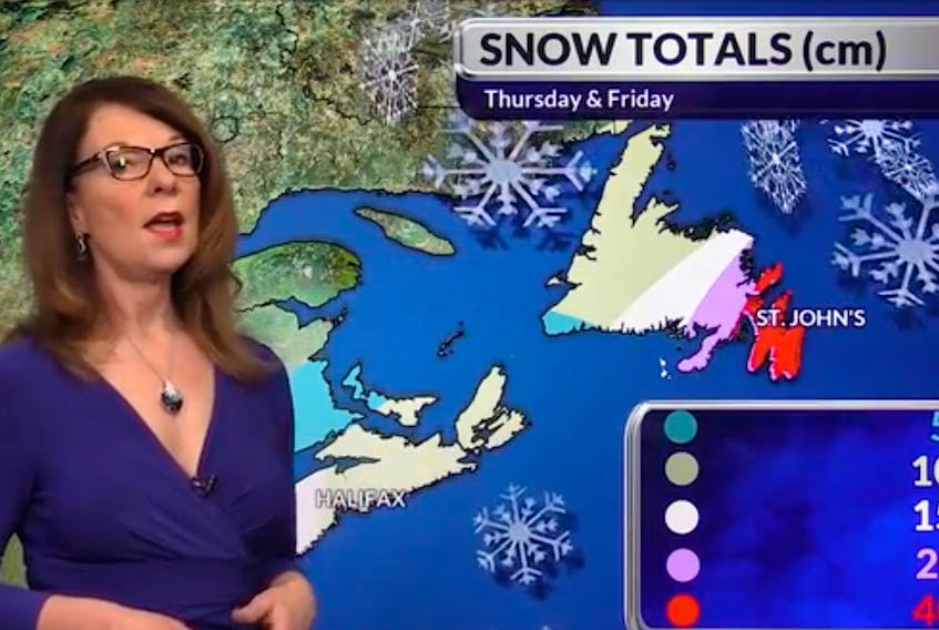
Expected snowfall amounts
Avalon and Bonavista Peninsulas: 40-60 cm (up to 70 cm on the Avalon)
Burin Peninsula and Gander area: 20-40 cm
Central and south coast: 15-20 cm
West coast and Northern Peninsula: 10-15 cm
Port aux Basques area: 5-10 cm
Watch Cindy Day's Forecast
View Cindy Day's most recent Newfoundland forecast.
Closures, cancellations and delays
This list of cancellations, including school closures, will be updated throughout Thursday evening and throughout the day Friday.