ST. JOHN'S, N.L. — However you choose to describe it — explosive cyclogenesis, weather bomb, blizzard or nor’easter — eastern parts of Newfoundland, especially the Avalon Peninsula, are in line for a lot of snow in the next day or two.
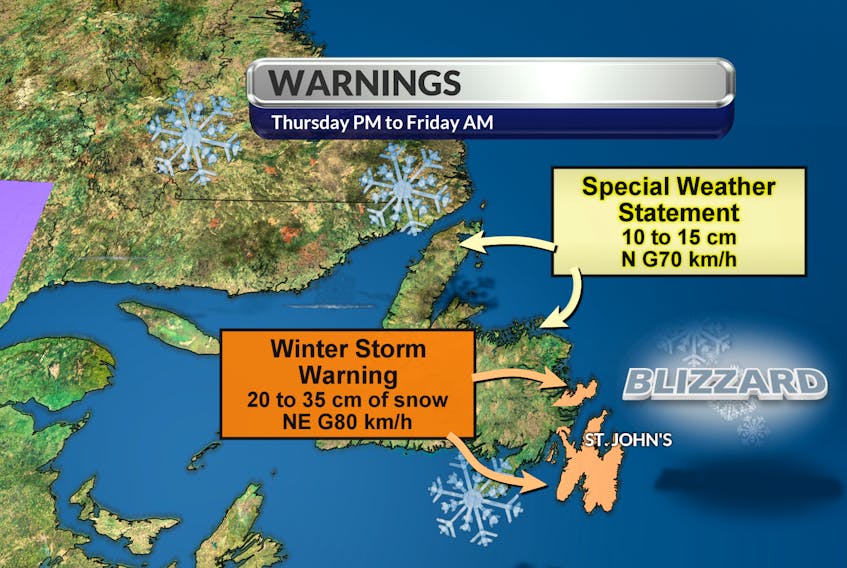
SaltWire meteorologist Cindy Day is calling for at least 30 centimetres of snow (a foot in imperial measurements) for much of Avalon Thursday into Friday. It’s solid precipitation that's been, for the most part, abnormally rare in these parts so far this winter. Before an overnight dusting Tuesday, most backyards in the metro St. John’s region showed nothing but grass.
That’s about to change and the snowfall will be all the more problematic because of forecast high winds resulting from a partnership of two low-pressure systems.
The first, the same one which brought that bit off snow overnight Tuesday, has moved north of the Avalon, but instead of heading east into the-Atlantic, it is doubling back a bit and waiting for the arrival of a friend.
Whenever that happens, expect them to engage in some winter weather mischief.
“There is big blocking high-pressure system over Greenland, so that first low is going to roll up along the coast and then spiral a bit,” said Day, before turning her attention to a more powerful follow-up.
That second low was 400 kilometres southeast of Cape Cod Wednesday afternoon, but is hustling along; Day predicts it will be 300 kilometres south of the Avalon by noon Thursday.
“Then, they’ll join hands and there will be a really unsettled pattern just off the coast,” she said. “And because (the second low) is tracking along pretty quickly, it’s intensifying. That means the wind field is going to be quite impressive.
Day calls for northeast winds gusting to 60 to 70 kilometres an hour Thursday afternoon before rising to 80-90 km/h from the north Thursday night.
The scientific name for what's being forecast is “explosive cyclogenesis,” which over the years has been simplified to the more universally-used “weather bomb.”
“It is defined as an area of low pressure where the central area of pressure drops 28 millibars or more in 24 hours or less,” explained Day.
“So, defining it by pressure, it is a weather bomb. But you can also define it by the conditions outside. Because there will be more than 20 centimetres of snow with high winds that will create near-zero visibility, it would also be correct to call this a blizzard, and because of the way it is tracking and the wind pattern around it, it’s also a nor’easter.
“Call it what you want, it’s going to be a big one.
“For the eastern and northern regions of the Avalon, I’d go a solid 30 (centimetres of snow), although it will be difficult to measure because the wind will be so strong."
The snow should spread as far as Gander, although Day predicts amounts will drop off as you move further west. As well, a fair amount of snow and/or significant winds are expected on the Burin Peninsula and along the northeast coast of the island, while the Labrador coast is looking at wind or blizzard warnings because of that low-pressure system which is hanging around.