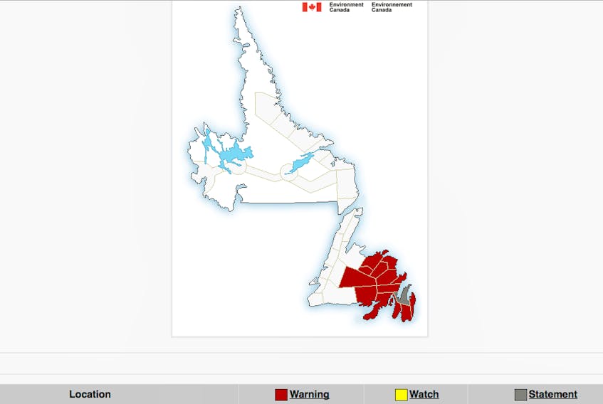
On Tuesday, Jan. 15 Environment Canada issued winter storm warnings are in effect for:
Bonavista North
Bonavista Peninsula
Burin Peninsula
Clarenville and vicinity
Connaigre
Gander and vicinity
Terra Nova
Hazardous winter conditions are expected.
Snow, at times heavy, will begin this morning, Tuesday, Jan. 15 then taper to flurries overnight before ending Wednesday morning, Jan. 16. Total snowfall accumulations of 30 to 40 cm are expected by Wednesday morning.
The heaviest snowfall is expected this afternoon into this evening. Additionally, winds will strengthen out of the north early this evening causing poor visibilities in snow and blowing snow.
Surfaces such as highways, roads, walkways and parking lots may become difficult to navigate due to accumulating snow. Rapidly accumulating snow could make travel difficult over some locations. Visibility may be suddenly reduced at times in heavy snow.
Winter storm warnings are issued when multiple types of severe winter weather are expected to occur together.
Snowfall warnings are in effect for:
Bay of Exploits
Buchans and the interior
Grand Falls-Windsor and vicinity
Snowfall with total amounts of about 15 cm is expected.
Snow is expected to begin near noon today, Tuesday, Jan. 15, with the heaviest snowfall expected late in the afternoon and early this evening. Snowfall accumulations of 15 to 20 cm are expected.
For Buchans and the interior, most areas are forecast to receive total snowfall accumulations of near 5 cm except over the Bay D'Espoir Highway area where total snowfall amounts of 15 to 25 cm are expected.
Conditions are forecast to improve near midnight as snow tapers off to flurries.
Be prepared to adjust your driving with changing road conditions. Rapidly accumulating snow could make travel difficult over some locations.
Snowfall warnings are issued when significant snowfall is expected.
Rainfall warnings are in effect for:
Avalon Peninsula Southeast
Avalon Peninsula Southwest
St. John’s and vicinity
Rain, heavy at times is expected.
Snow mixed with ice pellets and freezing rain will develop this morning, then transition to rain, at times heavy, by early afternoon. Total rainfall amounts of 20 to 35 mm are expected by tonight when the rain ends.
Heavy downpours can cause flash floods and water pooling on roads.
Rainfall warnings are issued when significant rainfall is expected.
A special weather statement is in effect for:
Avalon Peninsula North:
Wintry mix today and tonight, Jan. 15.
Snow mixed with ice pellets will begin this morning and will change to rain in the afternoon or early evening, then back to flurries overnight. There is a risk of freezing rain during the changeover. Strong easterly winds are expected to develop in the afternoon then shift to the northwest in the evening.
Snowfall amounts are expected to range from 10 to 15 cm with the highest amounts expected over the Bay de Verde Peninsula. Rainfall amounts will range from 10 to 20 mm
Conditions are forecast to improve early Wednesday morning as the system moves away.
Continue to monitor alerts and forecasts issued by Environment Canada at https://www.weather.gc.ca. To report severe weather, send an email to [email protected] or tweet reports using #NLwx.