Teddy will bring the heaviest rain along the south coast of Newfoundland up into the central regions when it arrives Wednesday, by which time it will be downgraded from a hurricane to a post-tropical storm.
After landfall Wednesday morning, Teddy will most affect Nova Scotia.
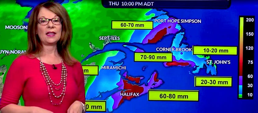
“With the suspected track of the system coming up along the west coast (of Newfoundland), there’s not going to be a great deal of precipitation along the west coast or even for the Avalon or the Bonavista or the Burin,” SaltWire Network chief meteorologist Cindy Day said mid-day Tuesday.
The south coast will likely see 60-80 millimetres of rain, with amounts dropping to 40-60 mm in the central regions of Newfoundland.
The Northern Peninsula won’t see much rain, but southeastern Labrador will get drenched.

“There could be 40-50 mm rainfall on the leading edge of that system — the northeastern quadrant — as it starts to come up the west coast of Newfoundland,” Day said of southeastern Labrador.
Again, the south and southwest coastlines of the island part of the province will see the heaviest winds — gusts to 70 kilometres per hour by 5 p.m. this afternoon, increasing to 100-120 km/hr, generally from the east-southeast, around midnight.
Those winds will drop off a bit in the morning, southeast gusting to 70 km/hr, and then pick up again to 100 km/hr on Wednesday afternoon and evening.
Wind warnings have been issued for the Wreckhouse area of Channel-Port aux Basques.

The St. John’s area will not see that kind of wind power, but it will see speeds of 60-80 km/hr.
The provincial government noted Tuesday a tropical storm watch and wind warnings have been issued for the southwest coast of the island, as well as heavy rain for southeastern Labrador and parts of western Newfoundland and strong winds for most of the island, with gusts up to 130 km/hr in the Wreckhouse.

Large waves, pounding surf and elevated water levels will accompany the system which could lead to localized flooding and coastal erosion.
Residents should avoid coastal areas if at all possible in the coming days. Conditions may be hazardous and emergency officials advise the public to use extreme caution, the province said in a news release.
Municipalities and local service districts were asked to review their emergency management plans and should ensure that infrastructure such as roads, ditches and drains are clear of debris and appropriate provisions are made for the delivery of services during the anticipated weather event. Preparations to protect vulnerable coastal locations should begin as soon as possible given the potential of damage to infrastructure, the province said.

Residents should always have a basic emergency kit available and be prepared for at least 72 hours, with food, water, batteries, a portable radio and prescription medications.
Drivers should consider the forecast before any road trip and check the provincial road conditions using the NL 511 app or visit nl511.ca.
Hurricane season runs until the end of November. Visit Get Prepared for more information on emergency preparedness.