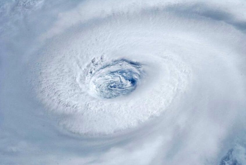
“There’s no threat to land until sometime early to mid-week next week,” said meteorologist Bob Robichaud, speaking with The Telegram after checking the latest forecast.
On the heels of the devastation caused by hurricane Harvey in the southern United States, it was only natural for there to be a flurry of inquiries to the hurricane experts, with more pressure for Robichaud and others to be able to say where Irma was headed and when — not to mention predicting its power on arrival.
There were further questions relating to climate change and what the future holds.
Warmer water temperatures are a factor in considering what hurricane season might look like, Robichaud suggested, as hurricanes require the warm water to form, and higher atmospheric temperatures would hold more moisture, but there are other factors.
“High wind sheer is significant. So, changes in wind, either speed or direction, as you go up in the atmosphere,” he said. “Hurricanes need an environment that doesn’t have a lot of wind sheer in it and one of the things we might see with climate change is potentially more wind sheer. So if there’s more wind sheer, there may be actually fewer hurricanes in the future as a result of climate change, but the ones that we do get may be a little bit stronger.”
RELATED LINKS:
NOAA 2017 hurricane season predictions
Hurricanes and climate change — NOAA
There’s an expectation of heavier rainfall events, particularly moving into the latter half of the century. Essentially, the bad storms are likely to get worse.
At the same time, sea level rise caused by climate change is increasing the chance for severe storm surge damage.
Isaac Ginis, a professor with the hurricane modeling group at the University of Rhode Island’s graduate school of oceanography, said it is not a good idea to point to any one or two weather events at any point and hold them up as the result of climate change. However, Ginis suggested the conditions spawning hurricane Harvey and hurricane Irma this year are likely offering a taste of what the future for tropical cyclones might look like.
“Hurricane Irma is not connected directly to climate change as a single event, but in the future climate we might see more often hurricanes like Irma, being able to maintain strong intensity for longer periods of time,” he said, noting the storm was fed by more than just warmer sea surface temperatures, but also the ocean heat content — the total heat energy in the upper ocean, reaching beyond the surface.
Specific to eastern Canada, Ginis said it’s important to watch for warm water reaching further north. Tropical cyclones and hurricanes moving north will be able to maintain higher intensity for longer periods of time as a result, entering the colder waters off Newfoundland and Labrador with greater energy.
Brian Walsh, a meteorologist in St. John’s with PAL Aerospace who also provides daily forecasting for VOCM radio, similarly advised against making any one storm all about climate change.
He was also tracking Irma early on, speaking with The Telegram when the storm was still a Category 3 hurricane, days away from first landfall.
“I’ve seen somebody had posted … on Facebook the National Hurricane Centre track and then they extrapolated it, put a post up saying Irma was going to go into the Gulf of Mexico and then go towards Houston,” Walsh said.
“That’s not what anybody is saying, but people can get all of these maps for free online. They can put up whatever they want.”
For forecasting whether any particular tropical cyclone is going to reach the province and whether more serious warnings are required, Walsh said models typically firm up and allow him to come to conclusions roughly five to seven days ahead of time.
By Sept. 6, while there were still some uncertainties about Irma’s track and intensity, the Canadian Hurricane Centre forecasted it would not reach Newfoundland and Labrador.
The province was not expected to see hurricane damage, at least not this time.
The updated 2017 Atlantic hurricane season outlook from the U.S. National Oceanic and Atmospheric Administration (NOAA), issued in early August, predicted a 60 per cent chance of an above-average hurricane season — with more named storms and major hurricanes — and only a 10 per cent chance of a below-average season.
“It is possible the 2017 hurricane season could be the strongest since 2010,” it stated.
That year, there were 19 named storms in the Atlantic Basin, an area including the Atlantic Ocean, Caribbean Sea and Gulf of Mexico — the third-highest count on record.
That year was a difficult one for Atlantic Canada, thanks to names like Earl and Igor, both being Cape Verde storms like Irma, beginning off Cabo Verde, a nation of islands off northwestern Africa.
Earl landed as a Category 1 hurricane in Nova Scotia, with sustained winds of 110 km/h. The storm moved into New Brunswick, with related rainfall peaking at about 75 millimetres.
Igor arrived in Newfoundland with winds gusts to 172 km/h, with 238 millimetres of rain recorded in St. Lawrence. The intense rain dropped across the island blew out culverts, severed roads and isolated more than 150 communities. One man, Allan Duffett, was killed.
NOAA researchers say the catastrophic flooding from the rain of hurricane Harvey was primarily due to the slow movement of the storm over Texas, while “there is scientific evidence that increasing water vapour in the atmosphere associated with climate change may be increasing the rainfall amounts in extreme weather events, potentially increasing the severity of flooding in storms such as hurricane Harvey.”
Looking ahead, in a review of available scientific research led by Tom Knutson at NOAA’s Geophysical Fluid Laboratory in New Jersey said global warming will likely, by the end of the century, cause tropical cyclones to have higher rainfall rates than today’s average.
“In our view, there are better than even odds that the numbers of very intense (category 4 and 5) hurricanes will increase by a substantial fraction in some basins,” Knutson said, “while it is likely that the annual number of tropical storms globally will either decrease or remain essentially unchanged.”
RELATED
Lethbridge woman in Caribbean safe throughout hurricane Irma
Group’s vacation cut short by Irma
Hurricane Irma playing havoc with newlyweds’ travel plans
Former Pictou County resident evacuates ahead of Hurricane Irma
Former Yarmouth resident grateful Hurricane Irma wasn't a direct hit
Doug MacLean’s daughter leaves Florida, another P.E.I. native will stay