ST. JOHN'S, N.L. — It’s still developing in the upper levels of the atmosphere, but the Atlantic region can expect a powerful storm beginning Thursday and continuing into Friday, Saltwire Network meteorologist Cindy Day says.
“The first snow we’re going to see over the western regions of the Maritimes will be about sunrise Thursday,” she said.
The storm will reach Newfoundland on Thursday just after sunset. Labrador can expect a small amount of snow on the southeastern corner, but otherwise will be relatively unaffected.
“Everybody gets weather from the storm, but it’s going to be a more powerful storm for Newfoundland,” Day said, noting the storm will hit hard on the southeast coast around the Burin and Avalon peninsulas before heading north.
“Gander will get probably 30 or more centimetres of snow and very strong winds to push it around,” Day says.
As the storm leaves mainland Nova Scotia, hitting Cape Breton around 2 p.m., it will deepen, and continue to intensify as it crosses Newfoundland, she says. However, the southern portion of the Avalon Peninsula may see some rain instead of snow.
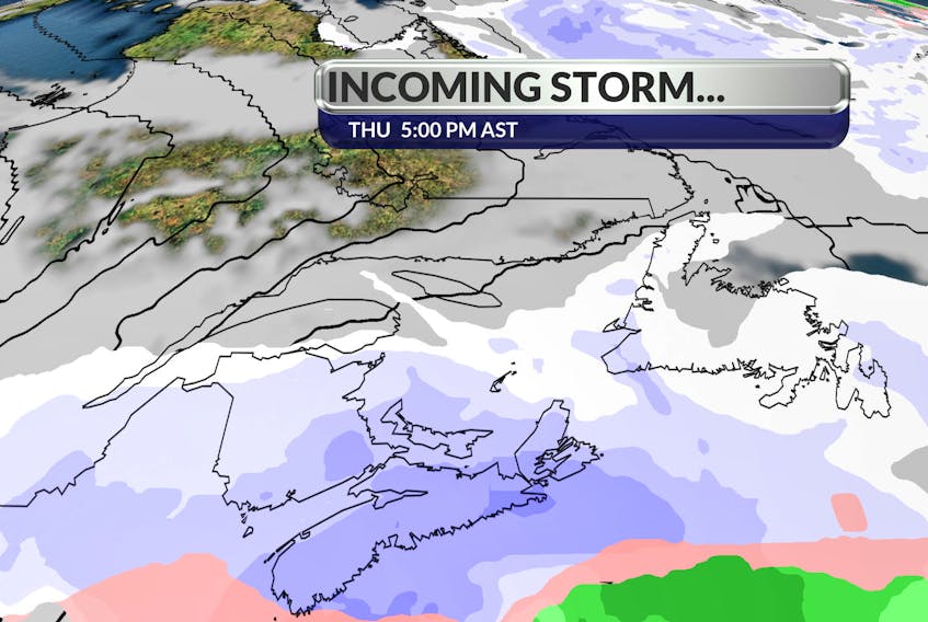
We have tomorrow to prepare for a wind & snow #storm. The snowfall map below shows snow totals from the start of the storm to the end of the onshore snow in its wake. Click on the link for time-lines and your local #forecast details: #nlwx #NSStorm https://t.co/YZwKDMfLnX pic.twitter.com/3uQqbLpuW3
— Cindy Day (@CindyDayWeather) January 14, 2020
“(The rain) will keep the snowfalls a little lighter, maybe 10 to 15 centimetre,” Day said. “That’s why up through Gander you’re going to see (more) because there’s not going to be that transition there.”
The potential for rain combined with below-minus temperatures on Friday evening and Saturday could cause a lot of ice. Day says this storm is on a fairly normal track for mid-winter, but what is exceptional about it is the wind speed.
“This system is going to have wind gusts to about 130 km/h on Friday (on the Avalon),” she said. “While there is going to be a lot of snow, the wind is going to be the challenge.”
Central Newfoundland will see wind gusts up to 80 km/h, while the west coast of Newfoundland will see about 60-to -70 km/h winds. The west coast of Newfoundland can expect the storm Friday around 3 a.m.
“But it’ll be a drier snow (on the west coast), so it’ll blow around even more,” she said. “It really becomes a blizzard-like system with poor visibility and all that wind to blow it around.”
Those in New Brunswick and Nova Scotia can expect to see this weather system at the same time on Thursday — just after sunrise. For New Brunswick, it’s not a big event, Day says.
“Because this system is actually going to sit and stay off the Atlantic coast of Nova Scotia, there’ll be five to 10 centimetres of snow for New Brunswick,” Day said. “Wind gusts (will be) 40 to 50 km/h.”
However, New Brunswick can expect another weather system on Sunday, with about 15 to 20 centimetres of snow and high winds. On Thursday, P.E.I. may see about 10 centimetres of snow with wind gusts of 70 to 80 km/h, beginning around noon.
“It’s really a mainland Nova Scotia, Cape Breton and then Newfoundland event,” she said. “(They) get the bulk of this system because of proximity to the centre of the low.”
“Everybody gets weather from the storm, but it’s going to be a more powerful storm for Newfoundland." — Cindy Day
But the strong north wind behind the system will continue to blow after the snow stops, causing crashing waves along the north coast of P.E.I. The wind chill will range from -18 to -25 C all day Friday across Nova Scotia, P.E.I. and eventually Newfoundland.
“There’s a very cold air mass behind the system,” Day says. And there is a risk of flooding for the northeast coasts of Nova Scotia and Newfoundland, including Sydney and St. John’s. A small amount of snow should come ahead of the storm, which may be deceiving, Day says. “
There’s an Alberta clipper that’s going to come in tomorrow, later in the day, and cross Newfoundland (and) all Atlantic Canada,” Days says.
An Alberta clipper is a storm that develops in the Rocky Mountain foothills, Day said.
“They get caught up in the jet stream and they race across the country. … They’re just a fast-moving system,” she says. This will happen overnight on Wednesday and finish Thursday morning, bringing with it a few centimetres of snow, before the larger storm begins.
Twitter: @andrewLwaterman