Newfoundland is gearing up for another major weather system due to hit the island this weekend.
Marine Atlantic, for one, is looking to get a head start in anticipation of potential disruptions.
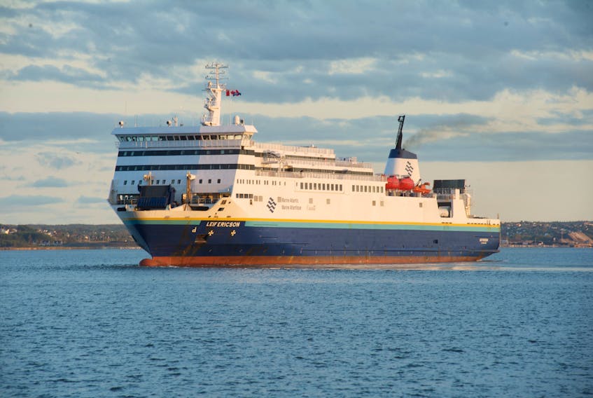
Marine Atlantic spokesman Darrell Mercer said the Leif Ericson will enter service Friday at 6:30 a.m. from Port aux Basques to help clear traffic in advance of the storm and address traffic backlogs if there's a service disruption. The vessel will be in addition to the regularly scheduled MV Blue Puttees and MV Atlantic Vision.
Mercer said Thursday Marine Atlantic made some adjustments and issued advisories for its schedule for this weekend: the MV Atlantic Vision will depart North Sydney at 10:45 a.m. Friday instead of the scheduled 11:45 a.m. to arrive in Port aux Basques before higher winds are expected to hit.
The MV Blue Puttees, however, is expected to leave on time from Port aux Basques Friday morning, he said.
Mercer said the schedule for Friday night’s crossings out of Port aux Basques and North Sydney and Saturday morning’s crossings out of each port may be adjusted. Vessel captains will continue to monitor the forecasts throughout today before making their final decisions.
NL Power crews ready
Newfoundland Power said in a statement it's always prepared for weather events.
The company is watching the weather system closely. It says its crews stand ready and prepared to respond for weather-related outages. Trucks are fully stocked and fuelled, and if required, crews may be deployed to locations where the storm is expected to hit the hardest.

Customers can call at 1-800-474-5711 or visit Newfoundland Power’s website for up-to-date information if outages occur.
The company encourages people to have an emergency kit ready and have electronic devices fully charged. The public is also reminded not to approach downed power lines, stay back a minimum of 10 metres (length of a school bus) and call the toll-free number (above) immediately.
NLESD guidelines
The Newfoundland and Labrador English School Board did not have any advance plans to close schools when asked Thursday. A district spokesperson said decisions on school delays and closures are usually made on the day of the weather event and parents of students should check the NLESD website (https://www.nlesd.ca/schools/statusreport/index.jsp), where guidelines and status reports are provided.
The spokesperson said there have been several occasions, including Hurricane Igor 2010 and the recent Snowmageddon 2020, where decisions were made in advance to close schools in light of weather forecasts, but noted those were rare incidents.
‘Bit of everything’
SaltWire chief meteorologist Cindy Day said the system will bring “a little bit of everything to everyone” in Newfoundland on Friday and Saturday.
Day provided an update for Atlantic Canada at noon on Thursday.
The low-pressure system will come ashore most likely near the Burin Peninsula Friday morning.
To the west of the Burin, it will be “mostly a snow event, and a lot of snow,” Day said.
The west coast can “very easily” expect 20-30 cm of snowfall, except around Stephenville, where there will be some mixing, resulting in totals that could be closer to 15 cm.

Day said snow will be heavy in central Newfoundland, with 25 to 30 cm forecast for Grand Falls-Windsor and approximately 15 to 20 cm for Gander. Near St. Anthony on the Northern Peninsula, about 15 cm. is anticipated.
There won’t be a true changeover to rain along the south coast to the Burin Peninsula, according to Day. That will mostly happen over the Avalon Peninsula, where southwestern regions will see temperatures hover around 2 C before colder air moves in.
St. John’s can expect about 10 cm of snow before a transition from freezing rain and ice pellets to rain.
Temperatures will warm up to three or four degrees on Saturday and start to fall in the afternoon.
Temperatures will drop sharply across the island, from west to east, on Saturday afternoon, Day said, causing icy conditions as the day goes on, particularly in the east.
Wind will also be a factor with this system, according to Day.
Wind gusts on the Avalon are anticipated to reach up to 80 kilometres per hour Friday afternoon into Saturday morning.
“Thankfully, because of the mixing of the ice pellets, there’s not going to be a lot of blowing snow,” Day said.
“The closer you are to the freezing mark, the icier the snow, which … reduces that blowing-snow component.”
While it won’t be as windy on the west coast, the snow will be drier, which will affect visibility on Friday and Saturday.
Highlights of Newfoundland and Labrador English School District's snow days policy:
• With respect to weather, the district recognizes families are in the best position to judge whether a student can travel safely to and from school and bus stops.
• Authority to close schools and/or school zones due to weather is delegated to the authorized zone administrator, usually a principal or assistant principal. Where a school system is impacted, the authorized zone administrator is advised to consult with the other school administrations.
• Closure or delay decisions are generally announced between 6:30 a.m. and 7 a.m. on the day the weather is taking place through local media — generally radio —and through status central on the main page of the district's website (www.nlesd.ca).
• Notices of closure normally indicate there will be a further update later in the morning, generally around 10:30 a.m. or 11 a.m., with delays communicated for a specific number of hours. Closures for the entire day are announced in the circumstance of a major weather event.
• Schools may not necessarily close early because the weather is deteriorating while school is in session. It may be prudent and safer for students to remain in school during the peak of a storm.
• Weather criteria taken into consideration when deciding a delay or closure include snowfall; wind; visibility, temperature; and road conditions.
• Authorized zone administrators are provided weather forecasts from a contracted weather service and they can consult with their student transportation staff or contractor, local municipalities or the Department of Transportation and Works.
Source: Newfoundland and Labrador English School District