ST. JOHN'S, N.L. — The tropical depression Sally — the weakened weather system from the hurricane that battered the U.S. Gulf Coast this week — is going to hose some serious rain on eastern Newfoundland.
“We’ve been watching all these tropical storms … hurricanes develop and we really haven’t been impacted by anything — all that stayed well off, 100 kilometres off Cape Race,” SaltWire Network chief meteorologist Cindy Day said.
That is until now.
“The energy or remnants from Sally will start to feed into a cold front,” she said.
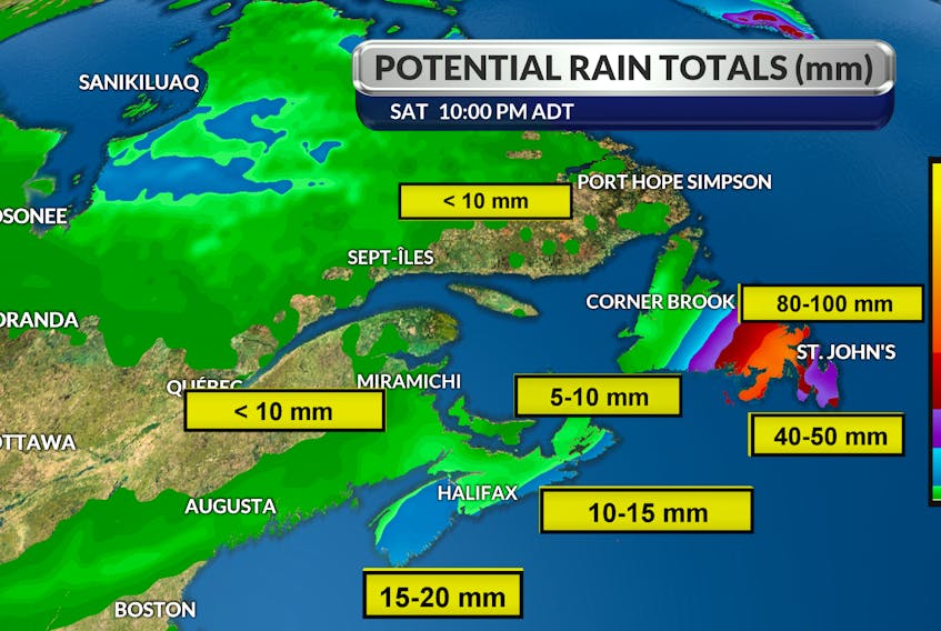
While Sally will bring only five to 10 millimetres of rain to the Maritime provinces, by the time it swings off the tip of Cape Breton, the energy from Sally will feed off that trough, Day said.
It looks like it is going to stall just west of the Burin Peninsula on an angle up across to the top of the Bonavista Peninsula, sitting there Friday night.
The heaviest rain gets going late in the day Friday and will be heavy overnight, but Saturday morning, it will start to ease up a bit, Day said.
But Friday into Saturday will bring rain that will be quite significant.
Just west of the Burin across the tip of the Bonavista is due to get 80-100 millimetres of rain.
The Avalon Peninsula is expected to see 30-40 millimetres, with a couple of pockets possibly seeing more, Day said.
“It’s going to be a pretty steady rain, but there is going to be bands of heavier tropical waves almost within it. You’re going to feel like you are on a beach somewhere at times the way the rain will come in these heavy waves.”
As the system heads west toward central, the rainfall amounts drop off to 20-30 millimetres, and the west coast will get not much more than five to 10 millimetres.
Winds from the south will not be excessive — gusting to 50-60 km/h Friday night, with 60-70 km/h winds Saturday morning, Day said.
Saturday afternoon, the wind flips around to the north to bring a clearing, cooler air and everything wraps up.
Sunday will be lovely, she said.
Meanwhile, Teddy is well south of Bermuda, and while its impact is up in the air at this point, it looks to be more of an event for Nova Scotia. and P.E.I. than Newfoundland and Labrador, Day said.
If it does hit this province, it will be Wednesday,
“Moisture from Sally heading into the weekend, a little bit of a break for a cooldown and all eyes on Teddy for the middle part of next week,” Day said.
The hurricanes and tropical storms are so plentiful this year that the World Meteorological Organization has run out of names — the last possible one being Wilfred — and will have to turn to the Greek alphabet.
“The sea surface temperatures are so warm that it looks like this is going to continue to be a trend with a very active Atlantic hurricane season. Even if they triple the number, it doesn’t necessarily mean we are in the path of any of them,” Day said.
“Because our water temperatures are so above normal off our coastlines, we’ll have to watch that closely. If the systems are set up that they start to track that way, they’ll keep their intensity because of our warm waters.”