ST. JOHN'S, N.L. — Schools right across Newfoundland and Labrador are reporting closures or delayed openings this morning as a storm system batters the province.
High winds and snow are impacting road, ferry and flight transportation.
SaltWire Network meteorologist Cindy Day said the snow is expected to continue throughout the day in most areas.
••••••••••
Previous story:
Snowstorm headed for Newfoundland and Labrador on Friday
Deer Lake mayor says town fortunate to have lots of space to move snow
The second-last day of February is set to kick off with yet another winter storm for Newfoundland and Labrador.
According to SaltWire Network meteorologist Cindy Day, the snow should begin after midnight Thursday and continue throughout the day Friday.
"It's an all-day Friday event," she said. "It's mostly snow. There'll be a brief changeover to a little bit of mixing at the tip of the Burin and Avalon, but it's mostly a snow event."

Cindy Day's Newfoundland and Labrador forecast
The Burin and Avalon peninsulas are currently projected to get less snow than the rest of the island, with Day suggesting a range of 10-15 centimetres. For the remainder of Newfoundland, snowfall amounts of 15-20 centimetres can be expected. Labrador City could also get 10-15 centimetres, Day said.
Winds for the Avalon will be southeasterly gusting upward of 80 km/h Friday, with gusts for the western half of the island generally in the 50-60 km/h range. While there's no clear sign of a Wreckhouse wind warning on the horizon, Day said she would not be surprised if that does transpire, bringing with it potential southeasterly gusts of up to 140 km/h.
A combination of sun and slightly warmer temperatures has evidently helped melt some of the accumulated snow on the ground, and Day said the weather following Friday's storm should offer some further aid in that regard.
"There's so much heat in that sun ... even at -5 C or -6 C if you're out of wind, it feels quite lovely," she said.
Immediately after the storm passes, conditions will be relatively mild before temperatures fall back below freezing Sunday, but only by a miniscule amount.
"There's no big cold snap, and then towards the end of the week next week, there's a little rain coming through with high temperatures near 4-5 C."
While there could be further significant snowfalls in March, Day does not anticipate any dips within the polar jet stream that could result in a cold spell for Atlantic Canada.

Hard winter
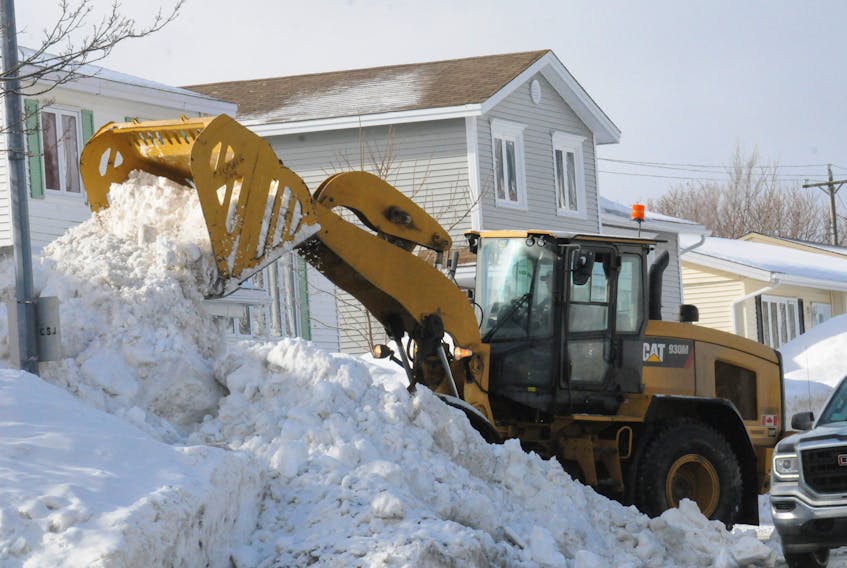
The winter has been hard on St. John's metro. Earlier this week, St. John's city council approved snow-blowback contracts totalling more than $829,000 to help out the city's east end. Mayor Danny Breen indicated at Monday's meeting some city-owned equipment is breaking down due to icy snowbanks.
For other municipalities, this winter has proven a little less challenging. Deer Lake — among the towns expected to get 15-20 centimetres on Friday — had 122 centimetres of accumulated snowfall on the ground as of Tuesday. Mayor Dean Ball told The Telegram snow this winter came relatively late for the western Newfoundland community of over 5,200.
"It's only the last three weeks that it seemed like when it started, it kept on coming," he said. "We have the space to put it, and we're kind of used to it. We have the workforce and the gear to handle the snow."
For a storm with 15-20 centimetres of snow, Ball said town plows can generally look after the job of clearing it in six to seven hours.
"We blowback snow on a regular basis to keep ahead of any snowstorms," he said.
"We can pretty much handle any amount of snow, I guess — almost. I shouldn't say that too loud. But we are used to snowstorms of 50-60 centimetres. We can handle that without any major grief." — Deer Lake Mayor Dean Ball
"We can pretty much handle any amount of snow, I guess — almost. I shouldn't say that too loud. But we are used to snowstorms of 50-60 centimetres. We can handle that without any major grief."
The mayor did acknowledge looking after all the sidewalks in Deer Lake can prove challenging as snow events come one after the other. The town usually begins to tackle sidewalks once roads are cleared.
Meanwhile, he does not envy the situation the city of St. John's and the rest of the metro area has faced this year as larger municipalities.
"We sympathize with the larger centres. They have a lot less places to put the snow," he said.
Twitter: @CBNAndrew