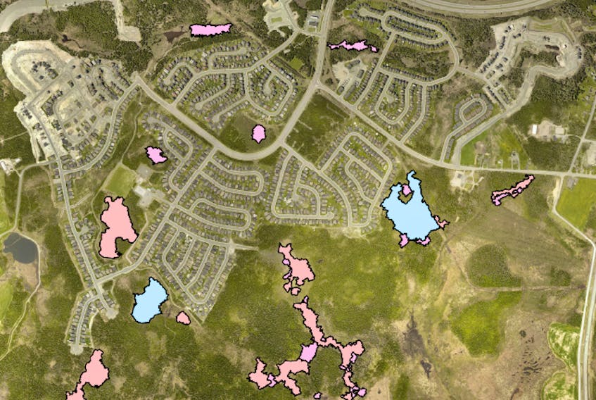
For the first time since 1993, St. John’s has a city-wide wetland study, identifying over 10,000 wetland components within the city.
That includes 1,790 bogs, 4,803 fens, 4,819 swamps, 1,341 marshes and 1,004 areas of open water within wetlands.
Mayor Danny Breen said it’s “very significant” to have the study completed because the city’s boundaries have changed drastically since 1993.
“We’re developing in areas that years ago weren’t even considered,” he said.
Breen said it’s important the city has the most updated information when making such development decisions, some of which have been quite contentious, such as around development in the Synod wetlands.
Breen said these are decisions that will need to be made, so it’s important to have correct information — “not to be talking about things that are conjecture, at times.”
The study was completed by C-CORE last year, and was done by remote sensing using satellite mapping.
The study was adopted by city council at its regular meeting on Monday, at which time councillors also voted unanimously to protect all wetlands within watersheds, as well as within the Goulds environmentally valuable area, floodplains and areas remote to development.
That left 17 areas, on which council voted to conduct a field assessment analysis that would classify the functionality of each wetland as either low, medium or high. These are areas that city staff said in the decision note will be “under pressure from development over the next 10-20 years.”
The city has already earmarked $350,000 for this detailed field survey study in its 2020 capital works budget.
Council also voted to require developers to conduct a field assessment on wetlands remote to development any time development applications are received by the city in those areas. The city would arrange the assessment, but the developer would pay for it.
The 17 wetlands to be part of the field survey are located in the following areas: Autumn Drive, Barrows Road, Bishops Line, Castlebridge Drive, Empire Avenue West, Galway, Harbourview Avenue, Kilbride South, Lundrigan’s Marsh, Outer Cove Brook, Pearltown Road, Southlands, Synod Wetlands, Viscount Street, Kenmount Road, Yellow Marsh and Kilbride East.
The survey is expected to be completed by early next year at the latest.
Coun. Maggie Burton said this is the first very comprehensive wetland study the city has done, and called it a “really important piece of work.”
Deputy Mayor Sheilagh O’Leary said this study was long-awaited, and in its absence without a wetland inventory the city often went down “a very messy road when it came to new development practice.”
O’Leary asked deputy city manager Jason Sinyard how this would impact the Waterford Hospital replacement, which the province plans to build on a flood plain. Sinyard said it will have no impact because the province is a higher form of government and trumps the city on such matters.
Coun. Ian Froude spoke about the many benefits of wetlands, including: acting as a stormwater buffer and reducing flooding, providing crucial wildlife habitat, giving people enjoyable green space, and cleaning water of contaminants.
Twitter: @juanitamercer_