That was quite a storm in eastern Newfoundland and Labrador! The weather has improved, but the system is still hanging around.
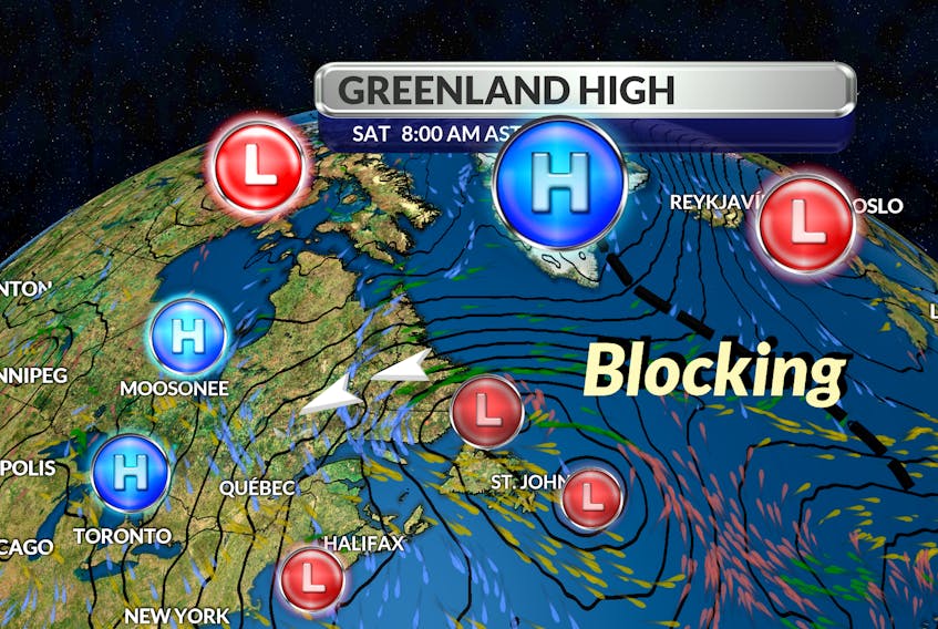
Most storms travel from west to east but not this one. The powerful nor’easter clipped the Avalon on Thursday, rolled up along the east coast of the island and now sits over the Great Northern Peninsula.
How come?
We can blame this retrograding pattern on the Greenland High or Greenland Anticyclone - a region of high atmospheric pressure over the glacial ice fields of the interior of Greenland. This high-pressure area results from the cooling of the lower layers of the atmosphere by the underlying ice surface. This colder air, being denser than the surrounding warmer air, produces the Greenland High.
Greenland is the world's largest island, located between the Arctic and Atlantic oceans. That’s pretty much all most of us know about it. We go about our daily lives and we don’t give it any thought. We should.
Greenland is one of the fastest-warming regions of the world, and while you might think that has no impact on you, think again.
A few years ago, research conducted at the University of Sheffield in England identified significant changes in weather systems over Greenland. Using a measure called the Greenland Blocking Index (GBI), they tracked the occurrence and strength of atmospheric high-pressure systems, which tend to remain stationary when they occur, causing long runs of relatively stable and calm weather conditions. The high pressure also blocks storm systems from moving in on the region.
This is where we should take notice. Researchers have found an increase in the incidence of high-pressure weather systems remaining stationary over Greenland since the 1980s, which is having a significant impact on extreme weather and climate change in the region. These weather systems are occurring in the area more often because of strong Arctic warming and changes in the atmospheric jet stream in recent years.
The frequency of extreme blocking over Greenland was found to have increased in the most recent two decades (2000–2019) compared to the previous period of 1980–1999.
So, while yesterday’s reversed weather flow might still seem unusual, it could become much more common in the future.
- Want more weather information? Visit your weather page.
- Have a weather question, photo or drawing to share with Cindy Day? Email [email protected]
Cindy Day is the chief meteorologist for SaltWire Network